Weather: Difference between revisions
(starting to add GRCA weather alert info) |
(text for the alert system) |
||
| Line 32: | Line 32: | ||
|} | |} | ||
To find specific Grand Canyon weather information, Tubby notes | To find specific Grand Canyon weather information, Tubby notes you can follow this [http://www.wrh.noaa.gov/fgz/ link] to the National Weather Service's Flagstaff site. Once there click on the map near Grand Canyon and it will zoom in. Click again on the zoomed map and it will give you a point forecast for the exact spot you clicked on. It's pretty amazing. | ||
Bessie notes the following NOAA weather forecast links come from the Grand Canyon National Park weather conditions | Bessie notes the following NOAA weather forecast links come from the Grand Canyon National Park weather conditions | ||
| Line 38: | Line 38: | ||
<span style="color:red;"><u>'''Grand Canyon Emergency Weather Alert System'''</u></span> | <span style="color:red;"><u>'''Grand Canyon Emergency Weather Alert System designed for texting devices'''</u></span> | ||
This project, funded by the USGS Risk Community of Practice, seeks to find ways of communicating the risk of flash floods and debris flows to hikers and boaters in Grand Canyon. | |||
In partnership with Coconino County Emergency Management, the National Weather Service, and National Park Service, the USGS has worked out pathways for alerts to move from the NPS or NWS to Coconino County for dissemination. This subscription-based emergency alert system was formally launched in late-March of 2024. | |||
Anyone can sign up for the Grand Canyon River Alert System using the signup number 1-928-707-7842 and text the message GCRIVERALERTS using a regular cell phone or a compatible satellite messaging device like Garmin InReach and SPOT devices. | |||
<u>'''NOTE: Some satellite messaging devices send additional characters or links in their outbound messages that would impede successful signup. This system requires that the only characters sent during subscribe are GCRIVERALERTS and any other characters will result in a failed sign-up and the user will not be notified that it failed. A user will know they are successfully subscribed when they receive the 'success' message (“You have successfully subscribed to receive Grand Canyon River Alerts.”).'''</u> | |||
Best practice is to test what an outbound message looks like by sending one from the satellite messaging device to a personal email first. If there are additional characters, they can usually be removed in the device settings either on the device or in the user's online account for their service provider. | |||
<u>'''NOTE!!! Users are automatically unsubscribed on Nov. 1 of each year to prevent over messaging if a user forgets to unsubscribe following a trip.'''</u> | |||
If you have a regular cell phone and are within cell service around the canyon (or not around the canyon and just interested) or if you have a compatible satellite messaging device and are in the canyon itself, alerts will be transmitted to you. | |||
Click [[The Pre-Trip Planning | '''here''']] to return to '''The Pre-Trip Planning''' page. | Click [[The Pre-Trip Planning | '''here''']] to return to '''The Pre-Trip Planning''' page. | ||
Latest revision as of 07:44, 1 July 2024
Scroll down for information on the Grand Canyon Emergency Weather Alert System
Summers are very hot in the Grand Canyon. Winters do not get as cold as one might expect but the low angle of the sun in a deep canyon means a lot of shade. There is also a micro climate induced by the cold water which cools the air. The canyon walls create an inversion for the cooler, heavier air near the river. The inversion is around 10 feet in height. This can lead to competition in the summer for campsites that are near the river and in the inversion.
| January | February | March | April | May | June | July | August | September | October | November | December | |
|---|---|---|---|---|---|---|---|---|---|---|---|---|
| Max | 57 | 64 | 72 | 82 | 92 | 103 | 106 | 103 | 96 | 83 | 68 | 57 |
| Min | 37 | 42 | 47 | 54 | 63 | 72 | 77 | 74 | 68 | 58 | 46 | 38 |
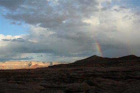
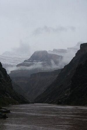
December through January can find snow falling at the river, and sticking below the Redwall as in this January photo. April through June are the dry months. The monsoon season starts in July, peaks in August and may extend into September. While it may seem strange to talk about monsoons in the desert, this is the northern extent of the summer monsoons of Mexico. Not only can there be rain in the monsoon season but it often is very intense and flash floods are common. The Navajo or Dine that live just to the east of the Canyon call this heavy intense rain "male rain". If you are in the Canyon during the monsoon season remember to take this into account when choosing camps, locating tent sites and hiking side canyons.
| January | February | March | April | May | June | July | August | September | October | November | December | |
|---|---|---|---|---|---|---|---|---|---|---|---|---|
| Average | 1.0 | 0.9 | 0.9 | 0.5 | 0.3 | 0.2 | 0.9 | 1.4 | 1.0 | 0.9 | 0.8 | 0.7 |
To find specific Grand Canyon weather information, Tubby notes you can follow this link to the National Weather Service's Flagstaff site. Once there click on the map near Grand Canyon and it will zoom in. Click again on the zoomed map and it will give you a point forecast for the exact spot you clicked on. It's pretty amazing.
Bessie notes the following NOAA weather forecast links come from the Grand Canyon National Park weather conditions webpage here.
Grand Canyon Emergency Weather Alert System designed for texting devices
This project, funded by the USGS Risk Community of Practice, seeks to find ways of communicating the risk of flash floods and debris flows to hikers and boaters in Grand Canyon.
In partnership with Coconino County Emergency Management, the National Weather Service, and National Park Service, the USGS has worked out pathways for alerts to move from the NPS or NWS to Coconino County for dissemination. This subscription-based emergency alert system was formally launched in late-March of 2024.
Anyone can sign up for the Grand Canyon River Alert System using the signup number 1-928-707-7842 and text the message GCRIVERALERTS using a regular cell phone or a compatible satellite messaging device like Garmin InReach and SPOT devices.
NOTE: Some satellite messaging devices send additional characters or links in their outbound messages that would impede successful signup. This system requires that the only characters sent during subscribe are GCRIVERALERTS and any other characters will result in a failed sign-up and the user will not be notified that it failed. A user will know they are successfully subscribed when they receive the 'success' message (“You have successfully subscribed to receive Grand Canyon River Alerts.”).
Best practice is to test what an outbound message looks like by sending one from the satellite messaging device to a personal email first. If there are additional characters, they can usually be removed in the device settings either on the device or in the user's online account for their service provider.
NOTE!!! Users are automatically unsubscribed on Nov. 1 of each year to prevent over messaging if a user forgets to unsubscribe following a trip.
If you have a regular cell phone and are within cell service around the canyon (or not around the canyon and just interested) or if you have a compatible satellite messaging device and are in the canyon itself, alerts will be transmitted to you.
Click here to return to The Pre-Trip Planning page.

